
Clearwater, Florida

support@landprecision.com

(727) 796-2737
35 + Years of Surveying
Over 35 years of Accurate & precise
Land surveying Services
Industry Professionals have relied on the Quality & Value of LPC since 1991 for all of their surveying needs.
SURVEYING, PLANNING & MAPPING
Founded in late 1991, Land Precision Corporation (LPC) has spent more than 35 years providing professional surveying support for land acquisition, commercial development, and infrastructure projects throughout Florida. Over the decades, our firm has built a strong reputation for delivering dependable, high-quality surveying solutions tailored to meet the evolving demands of developers, engineers, contractors, municipalities, and property owners. LPC specializes in a comprehensive range of commercial land surveying services, including Boundary Surveys, Topographic and Tree Surveys, ALTA/NSPS Land Title Surveys, FEMA Elevation Certificates and LOMA services, Platting Services, Construction Staking, and advanced Drone Surveying and Mapping solutions utilizing LiDAR and Photogrammetric Technology. By combining extensive industry experience with meticulous research and advanced state-of-the-art equipment, we provide accurate, reliable data that helps our clients move forward with confidence throughout every stage of their project. When it comes to commercial land surveying, LPC is committed to transforming vision into reality through precision, efficiency, value, and exceptional service.
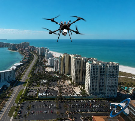
Why Choose a DRONE LiDAR Survey?
Land Precision Corporation provides advanced Drone and LiDAR Surveying services throughout the West Central area of Florida, delivering highly accurate, survey-grade data that supports land development, engineering, infrastructure, and environmental projects of every scale. By combining cutting-edge drone technology with high-density LiDAR data collection, LPC is able to generate detailed 3D mapping, topographic models, contours, and elevation data with a level of speed, precision, and efficiency that traditional surveying methods often cannot achieve.
Florida’s diverse terrain, dense vegetation, coastal environments, and complex regulatory requirements make LiDAR an invaluable tool for modern land development and planning. Our drone-mounted LiDAR systems are capable of rapidly scanning large and difficult-to-access areas while penetrating vegetation to capture accurate ground elevations beneath tree canopy and overgrowth. This allows developers, engineers, and project managers to quickly identify drainage patterns, flood-prone areas, elevation changes, utility corridors, and potential site constraints before major investments are made.
At LPC, our LiDAR services are supported by licensed Professional Surveyors and Mappers (PSMs) to ensure all deliverables meet Florida surveying standards and provide reliable, survey-grade mapping data — not simply aerial imagery. Our detailed LiDAR datasets can also support permitting efforts, environmental planning, stormwater analysis, wetland documentation, infrastructure design, volumetric calculations, and construction planning with exceptional accuracy and efficiency.
All of our Drone pilots are FAA Part 107 Certified.
Commercial land development is the foundation of our business, and delivering exceptional results is what sets us apart. At Land Precision Corporation, we combine industry-leading technology, highly experienced survey crews, and a knowledgeable professional staff to provide accurate, dependable, and high-quality surveying solutions for every stage of development. We consistently exceed expectations.
Precision isn’t just part of our name — it’s the foundation of everything we do. For over 35 years, LPC has earned a reputation for delivering accurate, dependable, and efficient layout services for projects of every size and complexity. Our skilled field crews and advanced surveying technology ensure that every point, line, and stake is placed with the highest level of accuracy keeping your project moving forward with confidence.

At LPC our advanced Drone and LiDAR Surveying services provide fast, accurate, and cost-effective solutions for today’s demanding land development and construction projects. With the ability to safely collect millions of data points across expansive or difficult-to-access areas, LPC delivers reliable results while minimizing field time and maximizing efficiency providing accurate & dependable data.
At LPC we combine meticulous research, advanced surveying technology, and extensive knowledge of ALTA / NSPS standards to deliver precise and accurate ALTA Surveys tailored to each project’s specific requirements. Our experienced team works closely with our clients to ensure that every survey is completed efficiently, accurately, and in full compliance with current ALTA/NSPS standards.
35+
YEARS IN BUSINESS
3K
PROJECTS COMPLETED
3.2K
HAPPY CLIENTS
8
COUNTIES SERVED
Featured Services

Topographic surveys are a critical foundation for successful site design and construction. By providing detailed mapping of elevations, utilities, drainage patterns, and existing site features, they give engineers, developers, and contractors the accurate data needed to plan efficiently, reduce costly surprises, and keep projects moving forward with confidence.
ALTA/NSPS Land Title Surveys are a critical part of commercial real estate transactions, providing detailed information on property boundaries, easements, improvements, access, and potential encroachments. At LPC, we deliver accurate, reliable ALTA surveys that meet the highest industry standards, helping developers, and property owners move forward with confidence.
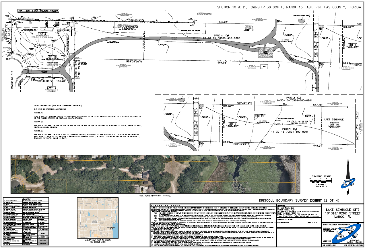
Commercial Boundary surveys are the foundation of confident property ownership and successful development. Whether you are purchasing, selling, or developing land, at Land Precision Corporation we provide accurate and efficient boundary surveys that clearly define property lines and deliver reliable data that meets the highest industry standards.

Our FAA Part 107 Certified pilots combine professional surveying expertise with advanced drone technology to deliver fast, accurate, and cost-effective solutions. Drone surveying significantly reduces field time, improves site accessibility, and safely captures detailed topographic, planimetric, and existing site condition data across large or difficult-to-reach areas.
LiDAR Surveying
Drone LiDAR surveying delivers highly accurate, survey-grade terrain data by using advanced laser technology to capture millions of ground points with speed and precision. This innovative solution creates detailed 3D models and bare-earth mapping, allowing developers, engineers, and contractors to make informed decisions faster while reducing field time and project costs.
Photogrammetry Surveying
Drone photogrammetry transforms aerial imagery into highly detailed maps and 3D models with accuracy and efficiency. By capturing overlapping images from multiple angles, this cost-effective technology provides developers, engineers, and contractors with valuable site data, helping improve planning, reducing field time, and accelerated project delivery.

Contact us Today